 |
 |
 |
 |
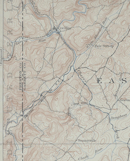
Downloading topo map files takes up a lot of file space, I appreciate my son, Matthew Cathell, showing me how to get the above down to a reasonable size. The map of Crellin and south is dated 1900 and shows the "Preston Lumber Co. RR" traveling south along the Yough to Breedlove West Virginia. 1900 is early for the line along the Yough according to Fizer( Glade Star Vol. 3 No.33), but perhaps this map was a later edition of the 1900 version. In any case, the Preston Railroad was 8 years old in 1900 and had been incorporated separately from it originator and largest customer, the Preston Lumber and Coal Company. 1900, although around the time of today's oldertimer's grandparents, was a really different world, at least in Garrett County! One striking difference was the road system. Many of today's highways were rudimentary farm roads. The once proud National Road, to the north in Garrett County, by 1900 had badly deteriorated. The Northwestern Turnpike, on the map above appears to be a secondary road. At the same time in Garrett County, the B&O and the West Virginia Central was the path of civilization and industry. The mill at Crellin had existed for sometime until it caught the eye of Pennsylvania lumbermen. Its location was the result of the enterprising Ashby family's need for lumber, thick stands of white pine and hemlock along the Yough and the water power potential of the Crellin area. The Pennsylvanians connected the Crellin mill with the B&O at Hutton Switch with a fairly new concept, a logging railroad. In the next 10 years, logging railroads would change the landscape of Garrett County and neighboring West Virginia for generations.
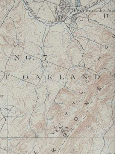
This author believes that the original B&O survey went through Crellin. The route would have been as follows: starting at Mountain Lake Park follow Trout Run to it source then cross a low summit to Douglass Run tributary of Cherry Creek near Gortner. Then it would follow Cherry Creek through a gap to the Yough near Underwood. The Yough subsequently makes a gap in Charcoal Hill to the Crellin location. The route would then use the same grade as the Preston Railroad along Snowy Creek, but would follow this creek all the way to today's Hopemont close to Terra Alta. This route was surveyed in the 1820's. The B&O finally built through this area in the early 1850's, taking a more direct route through Oakland, however much more fills and cuts were necessary than the Snowy Creek route described above. Another interesting feature shown on this map is that the Great Warrior Path or McCulloch Pack Horse Trail was still being used as a road from east to west. Route 39 from Oakland was not in in existence and Rt 219 would only improve the north/south Seneca Trail to modern highway standards in the Depression. The Preston Railroad played a part in that construction by hauling building materials to Breedlove on its former logging railroad along the Yough, after which the railroad was abandoned back to Crellin and operated for coal hauling only around the immediate Crellin area.
**************************************
The Preston Lumber Company whose mills are located at Crellin, Md. are extending their lumber tracks in several different directions in order to reach tracts of newly acquired timber and a large force of Hungarian laborers are hard at work on the extension. The company is doing a mammoth business at present and have yet several years cutting, which will keep the mill on its present site for some time to come. The railroad belonging to the Preston Company is now within a quarter of a mile of Aurora, and it will be pushed on further. It is the generally expressed opinion that the road - which is of standard gauge - will some day connect with the West Virginia Central road at Parsons. Indeed, the route has already been surveyed and right of way has been secured over the whole survey with but the exception of some four miles. The big saw-mill at Crellin is being run to it utmost capacity, and it is quite a busy scene to observe. The mill is equipped with every modern convenience for speed and a large number of hands are employed on the mill alone. The company's pay roll is an immense one and places thousands of dollars in circulation a month. The town of Crellin has grown rapidly and aside from it sufficiency of fleas, is a model little lumber town. - Kingwood Agnis.
From: The Historical Society of Kent County, Inc. � Phone: (410) 778-3499 � Fax: 410-778-3747
http://www.hskcmd.com/genealogical/counties7.html
GARRETT COUNTY 1903.
Garrett is the western most county of Maryland, and was created by an Act of the General Assembly in 1872, which divided Allegany County into two sections, naming the western end Garrett, after John W. Garrett, the well-known President of the Baltimore and Ohio Railroad, and contained a population of 17,701 in 1900. There are 681 square miles of area in the county, but with little, if any, water surface. It will be thus seen that Garrett is one of our youngest counties, and needs much development. The tax rate of Garrett for 1903 is 90 cents.
INCORPORATED AND OTHER TOWNS.
Oakland is the county seat, with a population of 1,170; Deer Park, Mountain Lake Park, Grantsville and Loch Lynn are other incorporated towns.
Other towns in the county not incorporated are Accident, New Germany, Bittinger, Friendsville, Swanton, Bloomington, Altamont, Button, Crellin, Thayerville, Avilton, Sunnyside, Kitzmillersville, Jennings, Beckman, Finzel, Hoyes, Grug and McHenry.
These numerous towns indicate rapid settlement of the county in the brief period that the county has been actually in existence, and is also an indication of great natural wealth, which lies to hand for development.
GEOGRAPHICAL DESCRIPTION.
Garrett is bounded on the north by the Mason and Dixon Line, which separates it from Pennsylvania; on the west by West Virginia; on the south and southwest by West Virginia, and on the east by Allegany County. The geographical survey divides the county into the Potomac Valley District, the Savage Valley District, the Glades Valley District, the Castleman Valley District and the Youghiogheny Valley District. Along the western boundary of the county there is an elevation of over 3,000 feet above sea level. This includes the crest line of the Great Backbone and Big Savage Mountains. Between these mountains lie a range of broad, flat-topped or gently arching hills.
The entire county is mountainous, but everywhere over the surface, covering hill and valley alike, is found a coating of soil varying in depth and grading imperceptibly into the underlying or resting directly upon the surface of the rocks. In the valleys the soil is usually deep and productive, and on the mountain slope it is shallow and stony. In some places the soil is stained a deep red, not altogether unlike the underlying beds of shale and sandstone. In other places the productive clays seem to bear no relation whatever to the deeply buried limestone, while on the mountain tops the soils seem but a mass of broken gray sandstone, mixed with small amounts of sand and clay. It is this soil covering with which the farmer has to deal.
This description is partially taken from the volume on Garrett County issued by the Geological Survey:
Mr. Clarence W. Dorsey, in his article on Garrett County, says: "Its surface is that of a broad, rolling plateau. * * *. The greater part of the county is well drained, but there are several areas of considerable size in the central portion which is swampy; these are known as glades. * * *. A large portion of the county is included within farm boundaries, and more than half of the farm area is not improved. The average sized farm is about 150 acres, but there are many which are over 1,000 acres. * * *. The soils consists mostly of sandy loams."
Taken as a whole, the soils of Garrett County, in the valleys, yield easily to cultivation; and the principal products of agriculture are buckwheat, oats, hay and potatoes, and a fair yield in some sections of wheat, rye and corn.
The principal manufactures of the county emanate from the forests, which are plentiful, and consists of lumber, shingles, staves and the mining of coal and shale.
CHIEF SOURCE OF WEALTH.
One of Garrett's chief sources of wealth is her minerals, coal, fire-clay and limestone. The George's Creek coal fields lie along the boundary line between Garrett and Allegany Counties, the major portion being in the latter county, but considerable of the coal being in Garrett The George's Creek coal is known all over the United States as being of a superior quality. Along the Potomac River, the southeastern boundary of Garrett, lies another field of coal, which is just being developed, it may be said.
While practically throughout the entire county coal may be found, as yet it is undeveloped, it being the smaller veins, and only being worked where it lies near to railroads. It can be said Garrett's resources are inexhaustible. It is only within the past few years that the small seams of coal are being worked, and as the years pass and the large veins become exhausted, it naturally follows that the small veins will be opened up more extensively. Fire-clay is found in abundance in some portions of the county, notably the northeastern section. Limestone is plentiful.
FARMS.
According to the census of 19oo there were 1,788 farms in the county, the estimated value of which, in 1903, is about $4,671,500, and the total assessed value of property in the county amounts to $7,612,488.
TRANSPORTATION FACILITIES.
Garrett is favored by good facilities for reaching the markets of the East and West, being traversed by the main line of the Baltimore and Ohio Railroad from east to west. The West Virginia Central and Pennsylvania Railroad follows the Potomac River along the southeastern boundary of the county. The Confluence and Oakland Railroad runs from Confluence, Pa., to Krug, and Jennings' Brothers Railroad from the Baltimore and Ohio, at West Salisbury, up to Castleman Valley to a point near Bittinger.
The old National Turnpike traverses the northern part of the county from east to west, while wagon roads throughout compare favorably with any other section of the State with a like mountainous nature.
THE COUNTY'S GREATEST NEEDS.
Being a new county, the question as to what the county mostly needs is hard to answer. Unquestionably, farmers would add greatly to its prosperity. It is an agricultural county and its future lies largely in that direction. While the deposits of mineral are large, they are not as compact and clean as in other places, while farming can be carried on even in the mining regions, and much land there is naturally drained and of a smooth surface. On account of the vast amount of humus in the soil in the "Glades" the land is of great value for producing such crops as require a moist and cool climate. There is great opportunity for truck farming in Garrett County, as well as the raising of stock. Dairying could be profitably engaged in. Land is plentiful and can be ought cheap, say from $5 to $40 per acre, and as the county offers considerable advantages for the raising of fruits, berries and vegetables, these industries could be profitably engaged in. Oakland, being but 11 hours from New York, and less to Baltimore and Washington, the mountain fruits and vegetables of a vigorous character, by reason of the pure air of the mountain tops, could be easily transported at profitable prices to these markets.
MANUFACTURES.
The manufacturing and mining industries comprise the principal industries of the county, and the following list may be of value for reference, though meagre in the figures furnished as to the amount of products:
Lumber and Timber Products
Yough Manor Lumber Company, North West Corners; Jennings Brothers, Jennings; Wilson Lumber Company, Wilson; Preston Lumber and Coal Company, Crellin; Meadow Mountain Lumber Company, Friendsville
Number of employees, 915; value of total product, $608,000; capital invested, $926,000; amount paid annually in wages, $399,200.
Tanneries&emdash;Number of employees, 40; value of total product, $260,400; capital invested, $150,000; amount paid annually in wages, $21,800.
Cheese, Butter, etc.
Accident Creamery Company, Accident.
Carriages and Wagons
A. D. Naylor, Oakland.
Flouring and Grist Mill Products
Henry A. Kaese, Accident; Noah S. Garlitz, Avilton; Stark & Ouster, Bittinger; Engle Mills, Cove; Yough Roller Mills, Friendsville; Eli Stanton, Grantsville; Geo. M. Mason, Rasche Roller Mills, Oakland; May & Leighton, Swanton.
Liquors, Distilled
M. J. Miller's Sons, Accident.
Lumber and Timber Products
Frederick Hoffman, Accident; Lancaster Manufacturing Company, Zachariah McKinzie, Avilton; Louis Littman, Peter J. Lohr, Murray, Rauch & Condron, Beckman; Durst & Youmer, Bevansville; Silas C. Beachy, C. J. Breneman, Bittinger; C. Holliday & Company, Cove; Jos. P. Moores, Cove Point; Solomon Hoge, Deer Park; Isaac Savage, Fearer; Crowe Brothers' Lumber Company, Finzel; Andrew Rhodes, Floyd; Bear Creek Lumber Company, Friendsville; P. C. Boucher, Herchberger Lumber Company, Grantsville; Frank J. Folk, Keyser; Yough Manor Lumber Company, Krug; Carney & Pendergast, Hutton; McAndrews & Simpson, Christian Otto, Bittinger & Wiley, New Germany; John R. Bowman, Brewmaker Company, Margaret Kerns, D. E. Offutt, Jas. E. Skipper, Oakland; Chas. C. Wilhelm, Sang Run; Ed. J. Frantz, Selbyport; M. D. O'Haver & Sons, Oss Brothers, West & Mosser, Swanton; North American Lumber Company, Bond.
Lumber and Planing Mill Products
F. G Fox, Friendsville: Kinsinger, Grantsville: Clarence W. Rathbun & Sons, Mountain Lake Park: Oakland Manufacturing Company, Oakland.
Photography
Hoffman, Friendsville; G. H. Pritchard, Oakland.
Printing and Publishing
Garrett Journal, Mountain Democrat, Republican, Oakland.
Saddlery and Harness
Henry Schubel, Friendsville; Jas. W. Leathers, Oakland.
Tinsmithing, Coppersmithing and Sheet Iron Working
A. D. Naylor & Company, G. A. Shirer, Oakland.
Toys and Games
Hartzell, Cressler & Company, Friendsville.
Tanning
Commonwealth Tanning Company, Hutton.
<
Preston RR Pages-use 'back' to return here
| Main page- No.18 & 19 | Art Huneke No.19 | Stan Mailer No.18 |
| Don Hensley No.17 | Bud Laws No. 16 | Preston RR 1901 Map |