=Broad Top Mountain Geology=
Note- this page contains a large map file-
The Unique Broad Top Mountain Coal Field
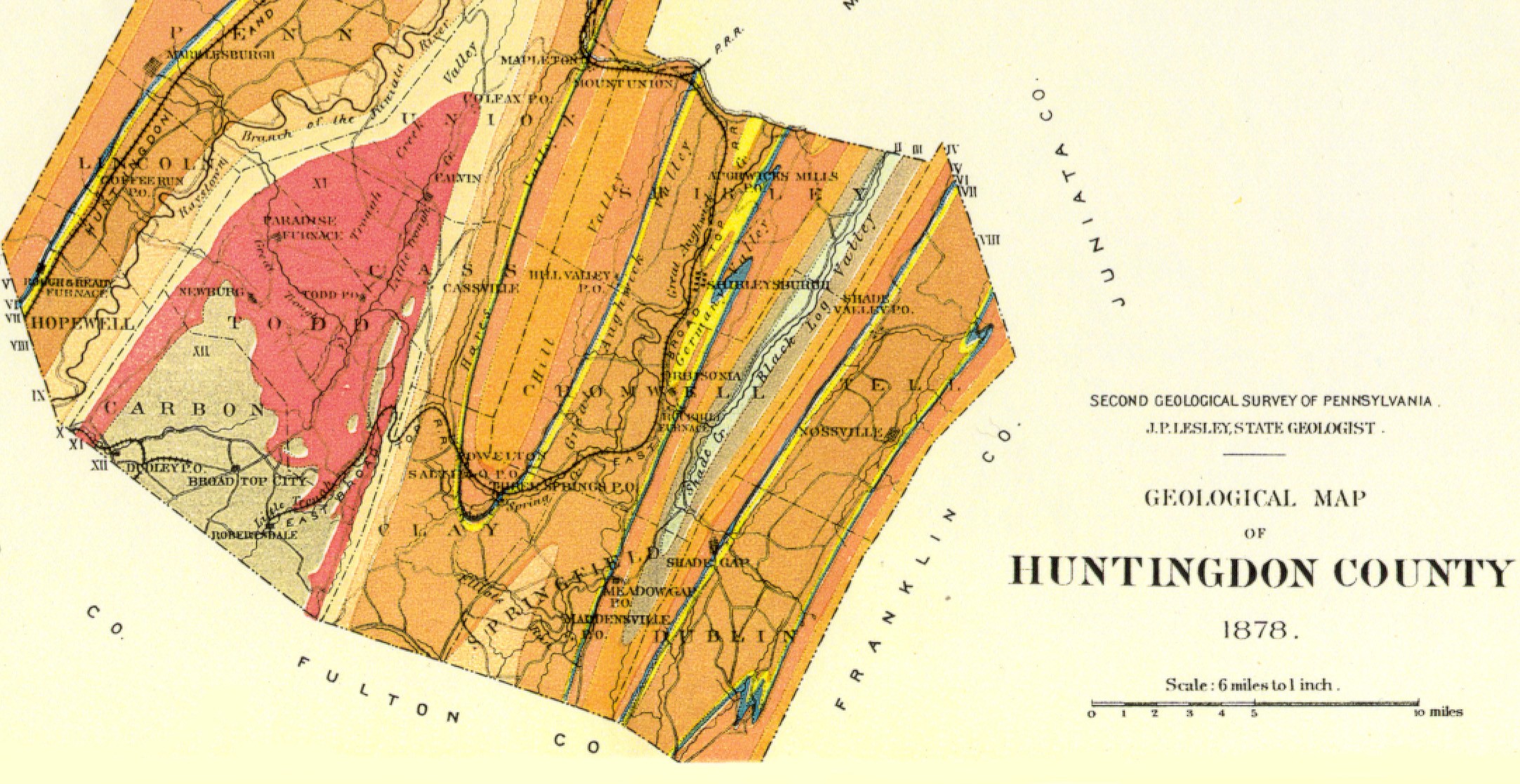
-The Broad Top Mountain coal field is unique in that it is a major coal measure located far to the east of the other Allegheny Mountain fields.
-Protection by the resistant Pottsville Sandstone formation and the pattern of streams are the reasons that left this coal field in place for human consumption while adjacent coal was washed to the sea millions of years ago.
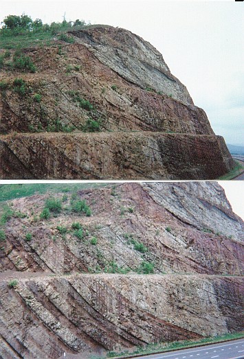
-Although on top of the present day 2000'Broad Top Mountain, the coal field is actually the bottom of an ancient deep synclinal trough. See the photos below of Sideling Hill in nearby Maryland to understand how this worked. Coal fields survive the erosion
of millions of years when they lie at the bottom of the ancient folds. The Broad Top trough was the deepest in Pennsylvania, according to the 1878 report below.
-The Broad Top Mountain coal field is unique in that it is a major coal measure located far to the east of the other Allegheny Mountain fields.
-There is semi-bituminous coal geographically to the east of Broad Top (for example, Sullivan County PA), however that coal is geologically west of Broad Top as the further-western Allegheny ridges bends sharply to east in Pennsylvania. One can speculate that the semi-bituminous coal on Broad Top becomes anthracite where the folding is more intense along the ridges to the left of Blue Mountain.
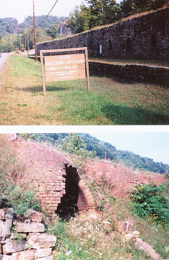
-Huntingdon County not only had coal, but also had iron ore and other minerals that would feed industry in earlier years. The abundance of coal and iron ore led to the development of transistional blast furnaces using coke a fuel that produced iron. Coke is a distilled carbon product derived from coal (much as charcoal is a distilled form of wood). Coke not only produced energy, but also provided a reduction medium in which oxides from the iron ore were removed. The third ingredient, locally quarried limestone, acted as a flux in removing other impurtities. In the photos below at Riddlesburg, we see the typical construction of coke ovens in this era. The top shows the reconstructed front of the oven battery. In the back where the stone shell has crumbled, the beehive construction of the brick inner oven is shown in the bottom photo. In this case, cook production was directly adjacent to the Broad Top coal source and the iron/steel production facility. In many other cases, coke ovens were adjacent to the coal source and the coke was shipped to the steel mill. Later, coke production was integrated with the steel mill after it was learned that the volatiles being cooked off had value for a variety of products ranging from plastics to sweeteners.
Much of this industry is gone, leaving a typical pattern of the natural resource dependent regions in other parts of the Alleghenies
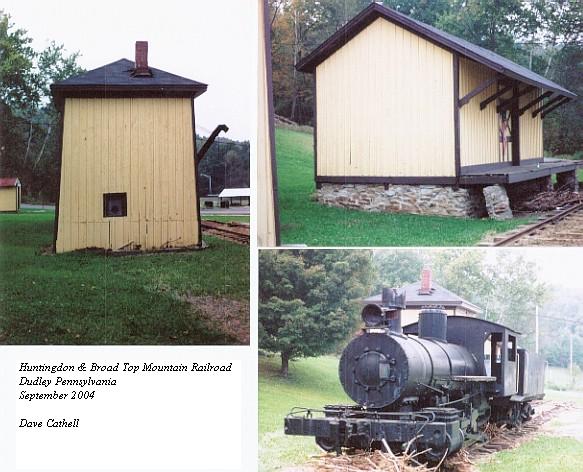
Huntingdon & Broad Top Mountain RR climbed east out of Saxton up Shoup Run, a typical branch to gather coal. Grades were steep on these branches, a switchback was used on this particular one to reach the top of the mountain at Broad Top City. The difficult grades and differences in guage were two reasons that H&BTM and EBT did not connect. Lack of potential interchange freight business was probably another. This particular photo was taken one week after the September 19, 2004 floods. Houses along Shoup Run were devastated in this area. Note the debris piled up in front of the locomotive.
******************************************************
Entire narrative from "Description of the Geology of
Huntingdon County
Pennsylvania"
Copyright © 2000, Pennsylvania State University Libraries. All rights reserved.
http://www.libraries.psu.edu/emsl/guides/X/huntingdon.htm
Through the middle of the large county runs, north north-eastward, the deepest synclinal trough in the State, and in its deepest portion (on the Bedford-Fulton line) has been preserved the Broad-Top semi-bituminous coal field, on a mountain surrounded by a mountain of No. X (Pocono) called Terrace mountain on the western side, and Sideling hill on the eastern; the two uniting in a knob (2000` A.T.) overlooking the Juniata valley at Huntingdon.The trough rises slowly northward bringing up successive curves of VIII, VII, VI, V, and finally IV in the Seven Mountains on the Clinton line. The east side of the trough being nearly vertical, the outcrops are straight and narrow, No. IV forming Standing Stone mountain; the west side of the trough being a very gentle slope, the outcrops are broad, and minor rolls in it produce the spurs of sandstone (VII) and limestone (VI) of Warriors Ridge, crowned by pulpit rocks, through which the Juniata cuts its picturesque gorge, 4 miles long, between Huntingdon, and Petersburgh, in which the nearly horizontal sandstone is seen overlying the limestone. Corresponding to the spurs of the ridge are spurs in Tussey mountain; and between the two sets of spurs, in the broad valley of Shavers creek and the heads of Mill creek, sweeps the zigzagged outcrop of the fossil iron ore beds of No. V, mined at Greenwood furnace in Jackson Township. Tussey mountain is gapped by the Little Juniata at Spruce creek, and by the main Juniata at Water Street, and then, after one anticlinal spur, runs straight on southward to Bedford county, carrying on its lower slope the block ore and fossil ore beds mined at Barree forge, at Marklesburg, and at points further south. No fossil ore is mined along the Standing-stone outcrop south of Greenwood, nor in Hares valley. The south end of Kishicoquillis valley, with its slate (III) and limestone (II) just enters the county. The Jacks mountain anticlinal arch is cut through between Mapleton and Mt. Union, and here the vertical Oriskany outcrop (VII) has been extensively quarried for glass-sand. Jacks mountain runs on south to Three Springs, where a fine fault has been pictured and described in Report F. The No. VIII valley of Aughwick creek separates Jacks from Black-Log mountain, along the west foot of which the Marcellus brown hematite ore (VIII) and the Clinton fossil ore (V) are mined at many points, especially at Orbisonia, where Black-Log creek makes a gap, through which runs a downthrow fault of 90`, mapped and described in Report F. The Black-Log anticlinal brings up III and II in a straight valley (2 miles wide) between Black-Log and Shade mountains, which crosses the county. East of Shade mountain runs the straight Tuscarora valley of V, VI, VII, and VIII, with traces of fossil ore, and bounded on the east county line by Tuscarora Mountain. Black-Log mountain south of Orbisonia is shivered by numerous very small cross faults, discovered in mining the fossil ore. On the summit of the mountain is a very remarkable deposit of brown hematite ore, connected with one of these faults. The north-west corner of the county covers the north end of Canoe Valley and the wide limestone (II) valley of Spruce Creek and Warrior Mark with numerous deposits of brown hematite ore. Tussey Mountain is faulted in the Spruce Creek gap, the fault being cut in the P.R.R. tunnel. The Juniata cuts a remarkable gorge lengthwise in the middle red member of IV, separating the ridge of White Medina from the higher ridge of Oneida, a very rare occurrence, and wildly picturesque. The anticlinal of Canoe Valley, between Tussey and Canoe mountains, is excessively steep and compressed, with a double fold along its crest line, and the Cambro-Silurian limestone strata (No.II) are thicker here than anywhere else in the State; for the extensive topographical survey of this region by Mr.Sanders (see the contoured sheets in Atlas to Report T) resulted in a measurement of (1) an Upper limestone series, 5400`; (2) Middle white limestone beds, 40`; and (3) Lower limestone series (including perhaps some beds properly belonging to the Potsdam formation No. I) 1160`, a total of 660 feet. As Canoe mountain ends in a synclinal knob at the Little Juniata River, the steep west dips of Canoe Valley give place to the gentle east dips of Sinking Creek valley up to Tyrone forges, where there is a fault, and the rocks immediately descend vertically westward in Bald Eagle mountain. Three miles north of the gap this mountain is faulted (1500`) crosswise, twice, so as each time to shift the terrace of Oneida sandstone into line with the crest of White Medina sandstone, making a beautiful piece of topography, mapped by Mr. Harden. (See Report T3.) The upper Medina is about 1170`, the lower red beds 520`, and the Oneida 1320` thick. The gorge of Little Trough Creek, splitting Rocky Ridge at the north end of the East Broad-Top coal basin, is one of the most picturesque bits of scenery in the State, and is of considerable geological importance. The limestone strata in No. XI red shale around Broad-Top is also most interesting as the beginning in Pennsylvania of the great sub-Carboniferous limestone formation of the Southern and Western States. The exposure of a group of small coal beds in the E.B.T.R.R. tunnel through Sideling hill (described in Report F) has thrown a clear light upon the nature and value of the numerous so-called discoveries of workable coal crops in the Pocono sandstone No. X, in various parts of Pennsylvania, none of which have ever answered the expectations of explorers. The group represents, however, the valuable sub-Conglomerate coal system of Virginia, Tennessee, and Alabama.
Excerpt of Celebrating a Century and a Half
The Geologic Survey"
by
Donald M. Hoskins
http://www.dep.state.pa.us/dep/PA_Env-Her/survey.htm
Frazer went to Bedford County and, starting at Hopewell, where coal was being mined, examined the rocks exposed in the gap of Terrace Mountain and then along the course of Yellow Creek through the gap in Tussey Mountain into the limestone valley of Morrisons Cove. (A geologists description of such rocks in their correct sequence is referred to as a "section." Such a section is frequently sketched in a geologists notebook in which the geologist will draw a picture of the rocks to show each layer in proper relationship to each other.) Frazers section began with the youngest rocks, and as he progressed, the section descended through geologic time to reveal that, along Yellow Creek, more than twenty-five thousand feet of rock layers of varying character were tilted such that they were vertical, or nearly so, over the whole section. He was able to demonstrate that the resistant sandstone layers underlying Tussey and Terrace mountains were, in fact, not the same, as had been thought by geologists who had previously examined the area. The sandstone and conglomerate layers supporting these mountains were, in reality, separated by many thousands of feet of intervening rock layers. Until this time geologists though that all of the ridges which make up the mountains of central Pennsylvania were supported by rocks of the same age.
Rogers, Frazer and Booth convened in Huntingdon on a Sunday in the summer of 1836 and compared their field notes. Frazers Yellow Creek section was disbelieved until confirmed by Rogers later that week in a visit to the area. Booth also verified the same sequence of rocks in a traverse along the Potomac River. The examination of the Bedford County geology in the first year of the survey resulted in the conclusion that the coals of the Broad Top Mountain were of the same geologic position and geologic age as were the bituminous coals known to exist in Clearfield and Lycoming Counties.
Prior to Frazers section, rocks which underlie the Broad Top and the surrounding areas included in the Appalachian Mountains had been thought to consist of rocks which would include veins of quartz, volcanic rocks and their included metal ores, as well as coal. What they found allowed a profound new scientific understanding of Pennsylvanias geology because it meant that exploration for coal in the rocks of the Appalachian Mountains, except in the Broad Top, was useless as no coal existed in these rocks.
Where Rogers and his assistants had expected to find in Bedford County ores of metals such as zinc and tin, they found, instead, a profusion of iron ores of the "brown" ore type.
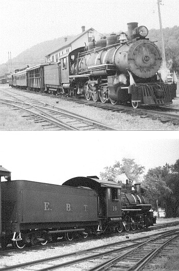 #14
#14
..
2004 EBT Fall Spectacular
EBT Pages
Official site of EBT

Friends of EBT
Rockville Bridge Rails Across the Susquehanna By Dan Cupper
Back to Cumberland Valley Railroad
Western Maryland Railway and Related Rail Links
Western Maryland Railway Yesterday and Today
World's Greatest Railroads!